

Alḥamdulillāh through the infinite grace and mercy of Allāh, I arrived in Saudi Arabia on the 29th of August 2022 to study at the University in al-Madīnah al-Munawwarah. That journey itself is something which I should document, maybe for another time.
Two months passed by settling in, acclimatising to the climate and getting used to the culture. Before I knew it, the first term was over and exams were round the corner. Upon completion of exams, a few friends planned to make a journey within Saudi to explore what the country has to offer. But as you will read on, what was meant to be a short trip ended up being a complete tour of the North and South of Saudi; from the border of Jordan in the North to Yemen in the South.
Still being fairly new in a country, the journey seemed daunting to say the least. A new country, left hand drive cars, and a whole load of other issues would be enough to dishearten anyone from our intended journey. The first task we faced was issuing our Saudi driving licenses. Holding a UK driver’s license whilst being a resident in Saudi means you are able to issue a license without going through the usual test route. We had our UK license translated officially at the Universities translation office, and then made our way to the driving school. If you stay in Saudi long enough, you will realise that ‘T’āl Bukrah’ (come tomorrow) is a norm, almost a cultured practice in official offices. This meant that we had to return the following day to the driving school as they only take 10 applicants a day in the license exchange office. I returned the following day, completed a short drive around the driving schools circuit, gave a blood test and later that evening after a tiresome four hours, received my Saudi license.
Coming from the UK, where given appointment times are followed to the letter, you start to appreciate the UK system in Saudi. Nevertheless, Alḥamdulillāh the Kingdom is working on and improving their government services as well as their customer satisfaction.
Two weeks remained till our planned journey. With exams coming up, the next two weeks were spent in preparing for and sitting exams. Exams finished on Tuesday 22nd of November, and that day went in looking for a car to hire. Alḥamdulillāh the process to hire a car for residents and visitors alike is straightforward. In Saudi, if you are looking for a particular thing, whether it be a car or a book, the shops selling the item will be in one area which makes it easier to compare prices.
Saudi Arabia
Saudi Arabia, officially the Kingdom of Saudi Arabia is a country in Western Asia. It covers the bulk of the Arabian Peninsula, and has a land area of about 830,000 sq. miles, making it the fifth-largest country in Asia, the second-largest in the Arab world, and the largest in Western Asia and the Middle East. It is bordered by the Red Sea to the west; Jordan, Iraq, and Kuwait to the north; the Persian Gulf, Qatar and the United Arab Emirates to the east; Oman to the southeast; and Yemen to the south. Bahrain is an island country off the east coast. The Gulf of Aqaba in the northwest separates Saudi Arabia from Egypt. Saudi Arabia is the only country with a coastline along both the Red Sea and the Persian Gulf, and most of its terrain consists of arid desert, lowland, steppe, and mountains. Its capital and largest city is Riyadh a modern metropolis. The country is home to Makkah and Madīnah, the two holiest cities in Islām. Pre-Islamic Arabia, the territory that constitutes modern-day Saudi Arabia, was the site of several ancient cultures and civilizations. The prehistory of Saudi Arabia shows some of the earliest traces of human activity in the world.
It is only very recently, in 2013, that the country decided to offer tourist visas to foreigners. Although the bulk of tourism Saudi receives is via Ḥajj and ‘Umrah Pilgrim’s, in more recent years, as the Kingdom has begun developing its many picturesque and historical beauty spots, especially the recognition of UNESCO sites in the Kingdom, it has become a tourist destination for Muslims and non-Muslims alike.

North KSA
Day 1- Wednesday 23rd November 22
Departure from Madīnah
Umluj
An early start to the morning, we left the University around 7.30am. Our first stop would be the coastal town, Umluj – a four ½ drive from Madīnah. Located in Northwest of Saudi, North of Yanbu, Umluj is one of the governorates of Tabūk and is known for its beautiful, clear turquoise waters, cotton candy sands and stunning coral reefs; thus deemed the ‘Maldives of Saudi Arabia’. Umluj is a haven for nature lovers and scuba divers, however currently due to the NEOM project, all boats and diving have been ceased till 2030. Umluj is a part of the Red Sea project, therefore ferries, boats, and large ships are banned from sailing in the area. This makes many Umluj tourist places untouched, quiet, and peaceful. It is an isolated gem that attracts travellers from all over the world. With its crystal-clear water meeting the blue sky at the horizon, the town also has reefs that add vibrant colours to the landscape, making the peninsula a dream destination.
Although it is recommended to visit Umluj between November and February where the temperature ranges between 25-30°C, the humidity makes it feel much warmer. We arrived at midday, took a short stroll on the beach and left just after ‘Aṣr Ṣalāh. Umluj was a short stop on our way to Tabūk which was another 500km – a drive lasting 5 ½ hours.

Tabūk
We arrived in Tabūk just before Midnight, making a stop on the way to pray Ṣalāh. Throughout our two-week trip, we found that apart from the main cities, the sheer size of the country meant most places seemed deserted. Coming from UK where a mile does not pass except, you’d spot a car driving past, in Saudi we would drive two or three hours and there would be no car in sight.
We would spend the next two nights in Tabūk, travelling to and from Tabūk to other locations. Tabūk is the capital city of the Tabūk Region in North-Western Saudi Arabia which became famous after the expedition of Tabūk in 9AH in which a 30,000 strong Muslim army marched North to Tabūk near the Gulf of ‘Aqba. Although there was no battle that took place, the Prophet ﷺ camped there for 20 days and made alliances with local chiefs. With no sign of the Byzantine army, they decided to return to Madīnah.

Day 2- Thursday 24th November 22
Haql , Georgios G Shipwreck, Al-Bada’, Maqna
A 6am start to the day, we had a long journey planned. The intended route would be to visit Haql, then come down the coastal route to see the Georgios G Shipwreck, Wadi Tayyib Ism, Magaher Shuaib, 12 Springs of Prophet Mūsā AS in Maqna and then return to Tabūk for the night.
Haql

Haql is a city in the North West of Saudi Arabia and is a 30-minute drive from the Jordanian Border. The mountains of Egypt and Jordan can be seen from the coast; in fact, we were in such close proximity to Egypt that our phone network had connected to the Egyptian network. Haql was a 2hr 45min drive from Tabūk. The drive from Tabūk through highways 395 and 55 passing through the Sarawat Mountains in the North-West of Saudi Arabia is truly a marvel for the eyes. Blue skies with sandstone mountains, occasionally passing by a herd of wild camels truly makes the drive special. Due to the proximity of Haql to the Jordanian border, on two occasions cars indicated for us to stop. Upon inquiry we realised they were trying to cross over to Jordan but didn’t hold the correct documentation. We took our leave and continued our journey.
We arrived in Haql around 10am, had some breakfast and stopped by the coast. The mountains of Egypt were visible from the pebble beach which lines the shores of Haql. Due to the lack of port use in Haql, it makes the coastal city a prime location for divers due to the clear turquoise waters, and coral reefs scattered along the beach. We didn’t spot any diving activities, but this may be due to us travelling out of season in the winter months.
Georgios G Shipwreck, NEOM

We continued our journey down South, taking a coastal route; a 45-minute journey along the coast of the Red Sea to our next destination, Georgios G, known as the ‘Saudi Titanic’. Georgios G is a 40-year-old Greek ship that got stranded near the city of Tabūk on the shores of Bi’r al-Mashī in Haql, near the Jordanian border. The ship was a cargo carrier and was built in 1949 in England three years after the end of World War II. It had many owners and several names until it was known by its current moniker.
One of its former owners, Saudi businessman Muḥammad Al-Senūssī, said that in 1978 the ship was crossing the Aqaba Gulf at night while loaded with flour on its way to the Jordanian port of Aqaba, but for unknown reasons it deviated from its course and stuck the coral reefs on the Saudi coast. The resulting damage left a hole in the hull and caused water to enter the vessel, leading to an increase in load and difficulty in movement. It has not moved since that day. After that, the Greek company running the ship decided to offer it for sale after examining the damage incurred. They found that the costs of repairing it were higher than receiving the insurance pay out, so Al-Senūssī bought it and delivered the flour in the ship to ‘Aqaba; the ruined goods were turned into fish food. Al-Senussi offered the ship for sale to a Jordanian businessman, and the latter sent an inspection team to repair it. During the inspection they tried to start the vessel’s engines, which then caught fire and burned for hours, ruining all its parts except the hull. The ship remained ever since, sinking further among the coral reefs as the waves moved.
During our drive to the Shipwreck, we came across countless signage posts for NEOM. This area as well as the shipwreck is under development for the NEOM Project. NEOM is a city being built in Tabūk Province in North-Western Saudi Arabia. It is planned to incorporate smart city technologies and function as a tourist destination. The site is north of the Red Sea, East of Egypt across the Gulf of Aqaba, and South of Jordan. The project has an estimated cost of $500 billion. We spent a short while near the shipwreck, had a walk along the sandy beach and continued on to our next destination.
Allāh’s creation in the Camel
Thirty mins into our drive to Wadī Ṭayyib Ism, we found the road closed with a no entry sign and a military post nearby. We parked up, and asked the army officer regarding the road. We were informed the road was closed as was Wadī Ṭayyib Ism for the NEOM development. He informed us of a new road that had been built which cuts through the desert and would save us time getting to Al-Bad’. We turned around and made our way to the new road. On the way we found a herd of wild camels, upon which a friend informed us of an incident he had heard regarding Shaykh Yūnus Raḥimahullāh: on one occasion whilst travelling from Makkah to Madīnah. Shaykh asked the driver to stop the car if he spots any camels. This was because he had not seen a camel previously and wanted to act upon the Āyah of the Quran, “Do they not look at the camels, how they are created?” [88:17]. Acting upon this we also made a stop and spent a few minutes marvelling upon this creation of the Almighty.
As for this Āyah, and why Allāh specifically says to ponder upon the creation of the camel – it is because the camel has characteristics which have not been granted to any other animal and if a person truly ponders upon its creation with a clear heart, it can only guide one to the creator. The camels’ characteristics are many, some of which are:
- Camels can travel up to 160 km per day (in 16 hours) in hot desert environment. And they can do it day after day after day. No other animal can even come anywhere near this performance. They can maintain a speed of 25 kmph for a long time and have a top speed of 67 kmph.
- Camels can survive dehydration of up to 40% of their body weight. Humans would die if we lose more than 12% of our body weight due to dehydration.
- Camels can drink huge amounts of water in one go i.e., up to 25% of their body weight without any ill effects. No other animal can drink this much water in one go as it causes intolerable dilution of blood and water toxicity.
The road which the Army officer told us to take looked as though it had just been completed. We didn’t come across a car for the 1-hour journey on the road. The road cuts through mountains and valleys and would be a dream for any car/travel enthusiast. We stopped over on the side of the road occasionally to admire the beauty and creation of Allāh. We were surprised to find that despite the development of urban and modern metropolises, we found Bedouins living within these remote areas, with nothing but a small hut and a heard of camels and sheep.

Al-Bada’ – Maghā’er Shu’ayb
We reached Al-Bada’ around 3:20 pm. The area was quiet with a few residents visible. We drove a little further out of the small town and reached Maghā’er Shu’ayb, also known as the ancient city of Madyan. The historical site lies 225km Northwest of Tabūk and is known for being the place where the Prophet Mūsā sought refuge after fleeing from Egypt. There he met the Prophet Shu’ayb who recognized in Prophet Mūsā a pure soul and gave him one of his daughters. Prophet Mūsā then lived for ten years with his wife and father-in-law in Madyan before returning to Egypt to free its people from Firoun. On his way back, his people crossed the Gulf of ‘Aqaba at the location named Wadī Ṭayyib Ism, also called the canyon of Moses. Most archaeologists agree that Al-Bada’ is the ancient city of Madyan, although there is no formal proof yet. There is an ongoing French archaeological mission that started in 2017 researching to confirm this hypothesis. This area dates back to the end of the 2nd millennium BCE.

This area is very similar to the Nabatean city found in Petra in Jordan and Hegra in Al- ‘Ula, although on a much smaller scale. We met a Saudi-born British National from Manchester who was working with the French archaeological company who are currently investigating this area. Upon inquiry he informed us he was working for NEOM, documenting this site and other historical sites within the area. As it was nearing sunset, he advised us to hurry to Maqna’ to the springs of Propher Mūsā so we are able to take a look before it gets dark. We took a short walk around the area and had a look inside the tombs and homes. We found them to be quite short in height. Some were tombs with visible areas where the graves had been dug and some were homes with different rooms within the mountain.
Maqna’- 12 Springs of Prophet Mūsā
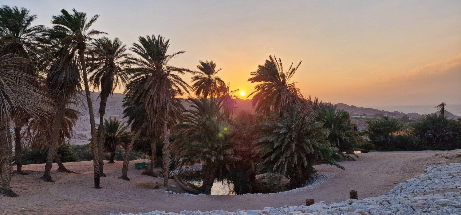
The drive to Maqna’ from Al-Bad’ was 30min on one straight road. We hurried there, being conscious of time. Although we had searched for the location of the springs over the internet, the exact location is not available on Google Maps. After receiving some help from locals, we were directed to the area. 12 Springs of Prophet Mūsā is a historical landmark located in the valley of Maqna’. A few kilometres before the coast, the palm trees intersect around small springs, and these springs pump water into the famous valley of Maqna’ through six sand holes driven by water that flows from the ground. Bir Al-Sa’idani, which is known as ‘The Well of Moses is where crystal clear water comes out of the ground in several places as if by magic. The well is surrounded by beautiful palm trees and its water runs downhill toward a lush palm grove. The sprouting of water and its flow against gravity in the middle of the desert appears to be nothing less than magical. This area is extremely beautiful and would be an oasis for anyone passing by.

Madyan is the land where Prophet Mūsā spent ten years in voluntary exile after fleeing from Egypt following an altercation with an Egyptian that was beating an Israelite. It is believed that Prophet Mūsā crossed the Red Sea and arrived in Maqna’ and went to the well called Bir Al-Sa’idani to drink. There he saw two girls collecting water for their cattle and he offered to help. The girls reported this gentle move to their father, the Prophet Shu’ayb , who went to meet Prophet Mūsā , he recognized his pure soul and decided to marry one of his daughters to him. Thus, Prophet Mūsā settled in Madyan and lived there for ten years with his wife and father-in-law.
As with all Pre-Muḥammadan history, scarcely recorded incidents results in uncertainty and often inaccuracies in establishing the exact locations of such places, hence you will find claims of the same well and springs of Prophet Mūsā in Jordan and other neighbouring Arabian countries.
This area is also under development for the NEOM project.

Coast of Maqna’- Gulf of ‘Aqaba

Just as the sun set on this coastal oasis, we made our way to the coast where the pebble beach meets with the Gulf of ‘Aqaba. Just on the other side of the Gulf, Egypt and the Sinai mountains are visible. This makes for a stunning sunset setting. Throughout our trip, we realised that Saudi has unlimited tourism potential due to its untouched beauty spots. With the current plans to develop the tourism industry in Saudi, places such as Maqna’, Al-Bad’ are soon to be tourist hotspots. Currently the coastal town, despite its breath-taking beauty was empty; we passed by a few residents and a few open shops. We left after sunset and made our way back to Tabūk for the night, it was a 3hr drive mostly through winding roads and minimal road lighting. We reached Tabūk around 10 pm, had some dinner and decided to visit Masjid al-Tawbah.
Masjid Al-Tawbah

The Al-Tawbah Mosque located in Tabūk is also referred to as the Castle Mosque due to its proximity to Tabūk Castle. Because of its link with the Battle of Tabūk, the mosque is considered a very important landmark in the Tabūk region. In 630AD, for 20 days, the Prophet ﷺ camped at the location of the Masjid which was near a running spring at that time. The Prophet ﷺ had arrived here with 30,000 men for the Battle of Tabūk. The famous battle was supposed to be fought against the Romans, but it did not take place. However, while the Prophet ﷺ was praying during his stay, Sūrah Al-Tawbah, the ninth chapter of the Qur’ān, was revealed, which is why the mosque is called Al-Tawbah Mosque.
Originally, the mosque was built out of bricks, mud, and palm tree trunks during the rule of Caliph Omar bin Abdul-Aziz. In 1652 the Ottomans rebuilt it, and the most recent reconstruction was done in the early 20th century. Now it has one minaret, a traditional arched entrance, and a massive prayer hall with plush carpet and beautiful chandeliers. Due to our out-of-hours visit, the mosque was closed. We stopped here for a short while, and then returned to our hotel for the night.
Day 3- Friday 25th November 22
Wādī Dīsah and Jabal Fīl (Elephant Rock)
Another early morning start, we left Tabūk shorty after Fajr Ṣalāh around 6.30 am and made our way to our next destination Wadī Dīsah. The morning chill in Tabūk reminds you of a nice cool summer morning back in the UK, and it brought back memories of home. The climate in Tabūk was much cooler and can get quite cold in the peak winter months. On our way down from Tabūk, we met two cyclists on the side of the road. They seemed foreign so we stopped over to ask if everything was okay. To our surprise they were Brits from the UK, and were heading to Tabūk on cycle; we wished them a safe journey and continued. Two hours in, we stopped at a small village called Ruḥayb; it was only then we realised how cold the temperature can reach in Saudi. It was 11 degrees and it was the first time during our journey we had to switch on the heating in the car. We reached Wadī Dīsah just before noon.
Wadī Dīsah
Wadī Dīsah, translated as ‘The Valley of Palm Trees’, is a mountainous region and one of the most beautiful natural landscapes in Saudi Arabia. The valley provides a secluded escape from the hustle and bustle of city life for those wanting to experience nature in its pure form. It is an untouched beauty spot which gives you a true feel of nature.

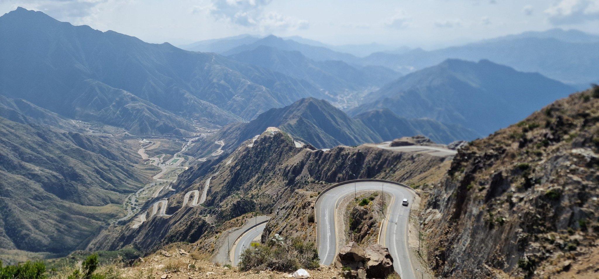
Nestled between the towering escarpments in the northern region of Saudi Arabia in the Tabūk Province, the valley lies 400 meters above sea level. Although the summers are not as hot as the rest of southern Saudi Arabia, it is better to visit the valley during winter. The valley has two entrances; however, the southern entrance is considered the more beautiful one. The valley floor is surrounded by huge sandstone cliffs that are perfect for exploration. The valley attracts many visitors every year as tourists can easily go camping or hiking due to the pleasant temperature during the winter months. Camping under the unpolluted night sky provides a breath-taking experience. Tourists often stay until the evenings to witness light playing on the sandstone cliffs during sunset.
The car we had taken was not suitable for the journey through the valley. At the entrance of the valley, you find drivers with 4x4s who can take you to explore the valley. We hired a driver at a cost of 250 SR and took the open-roof car trip through the valley. The valley was truly one of the highlights of our trip; the natural smell of greenery, coupled with the sandstone cliffs, occasional singing of birds, the coolness of the valley, and unpaved natural sand routes, truly gives you a feeling of ecstasy not found in the most beautiful of skyscrapers. We stopped occasionally within our route, to take pictures, drink from the fountains sprouting from the ground or pluck the mint leaves which grow within the valley. The experience through the valley cannot be transcribed in words and is a place worth visiting again. We came across many Arab families having picnics under the shade of the palm trees, and many visitors came into the valley as the day went on. We left Wadī Dīsah around 2 pm, for our next stop Al- ‘Ula, which was also to be our stay for the night. The journey was another three hours. We reached Al- ‘Ula around 4.15 pm, checked into our hotel and rested for a short while.

Al- ‘Ula- Jabal Fil

Al- ‘Ula, home to Saudi Arabia’s first UNESCO heritage site, is a name which has become more popular in recent times, and has become a tourist attraction for Muslims and non-Muslims alike due to its stunning natural rock formations, canyons, historical significance and immaculately preserved Nabataean tombs. The region encompasses more than 200,000 years of unexplored human history including the Nabataean city of Hegra, Saudi Arabia’s first UNESCO World Heritage Site: the ancient North Arabian Dadanite and Lihyanite Kingdoms, whose scripts contributed to the evolution of the Arabic language; and Al- ‘Ula Old Town, a stopping point for pilgrims from 1100CE.
Just before sunset, we left the hotel to get a glimpse of the naturally formed Jabal Fīl, also known as the elephant rock. Set in golden desert sands and climbing three storeys into the Arabian sky, the awe-inspiring elephant rock is one of Al- ‘Ula’s many geological marvels. Unlike the ornate, hand-carved facades of nearby Hegra’s Nabataean tombs, the body of this monolithic red sandstone beast was shaped by millions of years of wind and water erosion. The beauty of the unrefined structure is enhanced by a landscape of golden sands, studded with rocky outcrops, many of which are equally impressive in size and have interesting shapes and figures. We reached just before 6 pm and were lucky enough to capture a stunning sunset with a backdrop of sandstone cliffs. Shortly after sunset, we looked up to find a perfect view of the night sky. Due to the secluded location and its distance from the pollution of the city, the stars were clearly visible and could be counted individually if one wished. A perfect spot for stargazers. We spent a short while before returning to our hotel for the night.
Day 4- Saturday 26th November 22
Hegra, Ḥijāz Railway, Khaybar and return to Madīnah
Our last day in the North began with a usual early start after Fajr Ṣalāh. The plan was to visit Hegra, the Ḥijāz Railway, Khaybar and return to Madīnah, however as you will read on, not everything was as smooth as we would have liked.
Hegra
Hegra or al-Ḥijr also known as Madāin Ṣālih is an archaeological site located in the area of Al- ‘Ula within Madīnah Province in the Ḥijāz region. Majority of the remains date from the Nabataean Kingdom (1st century AD). The site constitutes the Nabatean’s southernmost and second largest city after Petra in Jordan, its capital city. Traces of Lihyanite and Roman occupation before and after the Nabatean rule, respectively, can also be found.
Once a major trade hub along the ancient Incense Route connecting the Arabian Peninsula with the Mediterranean countries, the vast 22,000-square-kilometer territory is a lasting reminder of the Kingdom’s pre-Islamic history: The Nabataean civilization which also built the remarkable city of Petra in Jordan left behind 111 immaculately preserved tombs carved into the sandstone rocks at Hegra. The tour requires pre-booking, which costs around 95 Riyals. We reached the meeting location for 8 am, checked in and waited until 8.30 am when the coach departed. The tour takes you around to a few key spots around the area, starting with the tomb of Liḥyān, son of Khuza’a’ – a stunning lone structure, iconic in its design and architecture.
Tomb of Liḥyān, son of Khuza’a’

Also known as Qaṣr al-Farīd or ‘The Lonely Castle’, is a well-known and iconic tomb in Madāin Ṣālih, in Hegra. The structure is said to have been erected in the 1st century CE and is unmatched when it comes to its ancient design and architecture, it was also the first site in Saudi to be declared a UNESCO World Heritage Site. The structure is designed entirely as a tomb. From the carvings and inscriptions inside the tomb, you can tell a lot about the Nabataean culture. The tomb is chiselled out of the rock from the top down which is an old Nabatean architectural technique and a major part of the Nabatean roots. Even though the architecture of this tomb is unrivalled, it appears that the entire structure was never completed. Towards the base of the tomb, the craftsmanship is not as precise, which can be observed rather clearly.
We were given an opportunity to ask questions to the tour guide, thus we presented a few questions:
Is Hegra the very area where the people of ‘Aād and Thamūd were punished?
To our question, the guide replied. This is not the place exactly. In the Hadith we find mention that the Prophet ﷺ whilst returning from the expedition of Tabūk passed by al-Ḥijr or Wādī al-Qura’ with his companions. They took water from its well for drinking and kneading the dough with it as well. When Allāh’s Messenger heard about it, he ordered them to pour out the water they had taken from its wells and feed the camels with the dough, and ordered them to take water from the well whence the she-camel of Prophet Ṣālih used to drink.
Upon further investigation, we have found that Wādī al-Qura was made up of several villages, many of which have not yet been uncovered. Hence it is possible that the area is still to be uncovered. One of the main reasons for our hypothesis is that the people of ‘Aād and Thamūd lived approx. 7000 years ago, and due to modern technologies, such as carbon dating, we can say for sure the tombs in Hegra are only 2000 years old.
The archaeological team only works two months in the year during the winter months due to the cooler climate. Every year they are discovering and uncovering new areas. Thus, the latest tomb that was uncovered was in 2017; when an opening of a tomb was uncovered due to rain. The tomb had the complete remains of the Nabateans along with other items.
If this is not the place of the people of Ṣāleh, why is it called Madāin Ṣāleh?
The attribution of this area to the Prophet Ṣāleh is a recent one; it began during the Ottoman Rule of Ḥijāz. Previously throughout this history, this area was known as Al-Ḥijr, as can be found on an ancient inscription at the site. The attribution to Ṣāleh is in fact linked to a wealthy and influential leader who lived in this area during the Ottoman rule whose name was Ṣāleh.
Allāh knows best regarding the attribution of al-Ḥijr to Ṣāleh and whether this was truly the place where the punishment of Allāh came upon the people of ‘Aād and Thamūd, nonetheless if it is, this was an opportunity for us to take heed from their final outcome and destruction. Allāh himself instructs the Prophet ﷺ to inform the people that they should roam the Earth and see the outcome of the evildoers.
قل سيروا في الأرض فأنظروا كيف كان عاقبة المجرمين
Travel through the earth and see what was the end of those who rejected Truth. [27:69]
What is the significance of this area?
Al-Ḥijr was the second largest city of the Nabatean Kingdom. The importance of Al-Ḥijr is due to two main factors:
- Its strategic location on the Frankincense Trade Roads, as the valley of Al- ‘Ula was the only easy path from the North to the South in between the lava fields of the Ḥarrat al-Uwayrid on the west and the steep canyons of the Ra’s al-Shatūb on the east.
- Its resources of underground water, supplied by the surrounding reliefs from where the rain flows down to the low plain that surrounds al-Ḥijr and feeds the table water that was just 10 meters under the surface at the time of the Nabatean Kingdom.
If the structures carved into the rock are tombs, where did the people live?
Only 10% of Al-Ḥijr has been excavated; the Saudi-French archaeological team are currently excavating the residential area. The guide showed us an aerial video of the area taken in a helicopter which shows the residential areas being excavated. A compound wall is visible as well as the homes. This area is not visible at eye level due to it being low; it can only be seen via helicopter.
Jabal al-Banāt

Our next stop was Jabal al-Banāt, a rock featuring over 100 monumental tombs, with 29 of them carved on all sides of sandstone rock. Jabal Al Banāt houses the highest cluster of female tombs. The tombs are decorated according to the wealth and status of those who built them. Some have stories written in ancient scripts at the entrance of the tomb and some have figures of Medusa to prevent grave robbers from entering. One of the tombs we passed by had the story of what we know today as Rapunzel inscribed. The guide informed us of how this story is found in different cultures across history with slight variations.
We were not allowed to enter any of the tombs due to the UNESCO heritage and preservation status but we did have an opportunity to take a peek inside and we found it to be of the same layout which we saw at Maghā’er Shu’ayb in Al-Bad’.
Jabal Ithlib
In the heart of Hegra, Jabal Ithlib is a glorious, natural mountain and a cultural site. Historically, it was a place of worship and a meeting place for the Nabateans.
The main attraction of Jabal Ithlib is the ‘Dīwān’ which is a large room carved into the rocks of the mountain that looks like a dining area or a triclinium. It is historically believed to have been an important room for gatherings such as royal banquets and political meetings and also has an open front, which was probably designed for outside or public observers. Its location serves as a perfect spot to relax away from the desert heat. It is located in such a place where the sun only hits for an hour a day and due to its surrounding mountains, it has a cool breeze throughout the year.

We were also treated to more recent Arabic inscriptions on the cliff faces of the rocks, which depicted a caravan travelling for hajj on camels and a language most likely a precursor to modern Arabic. There are many more tombs and rocks to be explored within the Al-Ḥijr site, but due to time constraints, this concluded our tour. An area that the tour did not cover was the Ḥijāz Railway. We enquired regarding its whereabouts and we were informed that it was closed for restoration work. Nevertheless, the Ḥijāz Railway fell on our route to Khaybar and then Madīnah so we decided to confirm if it was truly closed.

Ḥijāz Railway
The Ḥijāz Railway was originally designed to speed Muslim pilgrims from Damascus to the holy cities of Makkah and Madīnah. It was created primarily to establish a link between Constantinople and Ḥijāz. The line began in 1900 and spanned 1,600km from Syria to Madīnah by 1908, though its planned final leg to Makkah never materialized.
During the first world war, sections of the line were attacked by T.E. Lawrence and his Arab allies and by 1918, less than two decades after the project’s beginning, the railway lay in ruins. The track was unofficially abandoned by 1920. The stations at Hegra and Al- ‘Ula signalled the final point to which non-Muslims could travel before reaching Makkah. They opened in 1907, and in 1912. More than 19,000 pilgrims stopped at Madāin Ṣāleh which was one of the largest railway stations on the Ḥijāz railway and consisted of 16 buildings that date back to the Ottoman Empire. It is one of the most important stations along the Ḥijāz railway and was used as a rest area, accommodations and a restaurant for passengers. It consists of a workshop for the maintenance of trains and a small museum is now there within the main Madāin Saleh historical site.
Upon arrival, we realized that the area was closed and extensive restoration work was being carried out. The guard informed us that no one was allowed inside and neither was photography allowed. Our journey continued on to our next destination 2 ½ hrs away in Khaybar.

Khaybar
Khaybar is a city 153km north of Madīnah, in the Madīnah Province. It was once an oasis for Jews and was predominantly inhabited by Arab Jews before the rise of Islam and the subsequent conquest of Khaybar in 628 CE. The main attraction which we had planned to visit was Khaybar Fort, which has a significant place in Islamic history. The fort is where the Jews barricaded themselves during the famous battle of Khaybar. Muslims marched on the Fort and were able to force a surrender from the Jews, which marked the end of the famous battle. The Fort is located on a hill and is surrounded by palm trees. The ruins of the Fort are a mixture of Basalt and mud.
Upon reaching the area where the fort is located, we were stopped by an Army Security officer and prevented from driving any further. He enquired who we were and where we had come from. Satisfied with our response, he told us that there was no entry into the area unless you had written permission from the government. He told us to email the relevant department and ask for permission before attempting to come again. It is possible that the fort along with many ancient and historical areas are currently closed for restoration and plan to open for tourism before 2030.

We drove around the area, had a look at the old derelict buildings which seemed to have been built with the same Basalt rocks used in the fort, and eventually made the last leg of our journey back to Madīnah. We arrived in Madīnah just before Maghrib Ṣalāh, and this concluded our journey to the North of Saudi.